A) Iowa
B) Montana
C) Nebraska
D) North Dakota
E) South Dakota
G) C) and D)
Correct Answer

verified
Correct Answer
verified
Multiple Choice
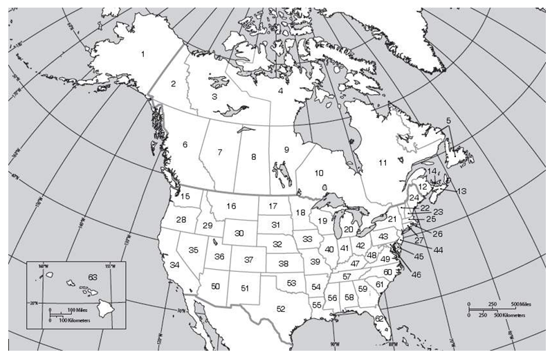
 -What is the name of the state or province labeled on the map with the number 20 (twenty) ?
A) Michigan
B) Montana
C) Minnesota
D) North Dakota
E) Wisconsin
G) A) and D)
Correct Answer

verified
Correct Answer
verified
Multiple Choice
What is the most abundant fossil fuel in the Unites States?
A) natural gas
B) oil
C) kerosene
D) coal
E) petroleum
G) A) and C)
Correct Answer

verified
Correct Answer
verified
Multiple Choice
 -What is the name of the state or province labeled on the map with the number 6 (six) ?
A) Alberta
B) British Columbia
C) Manitoba
D) Ontario
E) Saskatchewan
G) A) and E)
Correct Answer

verified
Correct Answer
verified
Multiple Choice
Wheat, cattle, and horses are common sights in North America today. Why?
A) They migrated to North America from South America.
B) Native Americans brought them to the region when they arrived 12,000 years ago.
C) These species are indigenous to the region.
D) Europeans brought them to the region.
E) All of the answer choices are correct.
G) A) and D)
Correct Answer

verified
Correct Answer
verified
True/False
Write True or False to the statements below.If the statement is false, rewrite the underlined word or phrase to make the statement true. -In the Electric Streetcar era of the Historical Evolution of the U.S. City, settlement developed along commuter routes, in some cases as far away as 40-60 miles from downtown.
B) False
Correct Answer

verified
Correct Answer
verified
Multiple Choice
Which of the following is NOT covered by the International Joint Commission?
A) water resources
B) transportation
C) environmental quality
D) cross-boundary issues
E) international terrorism
G) A) and B)
Correct Answer

verified
Correct Answer
verified
Multiple Choice
What was Henry Flagler's contribution to Miami?
A) He was Miami's first mayor
B) He built the first hotel in Miami
C) He invented air conditioning
D) He built a railroad to South Florida
E) He persuaded NBA great LeBron James to leave Cleveland's basketball team and join the Miami Heat.
G) A) and B)
Correct Answer

verified
Correct Answer
verified
Multiple Choice
Which of the following is a source of water pollution in North America?
A) mining operations
B) industry
C) municipal sewage
D) industry and municipal sewage
E) industry and municipal sewage, and mining operations
G) B) and C)
Correct Answer

verified
Correct Answer
verified
Multiple Choice
How does the median household income of Asian families in North America compare to that of white families?
A) It is 50% lower.
B) It is 10% lower.
C) It is the same.
D) It is 10% higher.
E) It is 50% higher.
G) A) and B)
Correct Answer

verified
Correct Answer
verified
Multiple Choice
 -What is the name of the state or province labeled on the map with the number 61 (sixty-one) ?
A) Florida
B) North Carolina
C) South Carolina
D) Alabama
E) Virginia
G) A) and B)
Correct Answer

verified
Correct Answer
verified
Multiple Choice
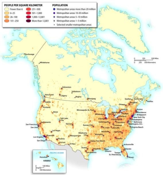
What region of the United States contains the country's densest population settlement?

A) the Midwest
B) the Atlantic Coast
C) the Pacific Coast
D) the Sunbelt
E) the Great Plains
G) C) and E)
Correct Answer

verified
Correct Answer
verified
Multiple Choice
The United States consumes about how many times as much oil as it produces?
A) one-half
B) equal
C) twice
D) triple
E) four times
G) None of the above
Correct Answer

verified
Correct Answer
verified
Multiple Choice
Which of the following statements is most accurate?
A) Canada is slightly smaller in land area than the United States, and its population is only about 10% that of the United States.
B) Canada is slightly smaller in land area than the United States, and its population is only about 20% that of the United States.
C) Canada is slightly larger in land area than the United States, but its population is only about 20% that of the United States.
D) Canada is slightly larger in land area than the United States, but its population is only about 10% that of the United States.
E) The United States and Canada have almost exactly the same land area, but the population of the United States is double that of Canada.
G) None of the above
Correct Answer

verified
Correct Answer
verified
Multiple Choice
 -What is the name of the state or province labeled on the map with the number 19 (nineteen) ?
A) Michigan
B) Minnesota
C) Montana
D) North Dakota
E) Wisconsin
G) A) and B)
Correct Answer

verified
Correct Answer
verified
Multiple Choice
What waterway opened up the Great Lakes to improved global trade connections?
A) St. Lawrence Seaway
B) Mississippi River
C) Rio Grande
D) Colorado River
E) Columbia River
G) A) and B)
Correct Answer

verified
Correct Answer
verified
Multiple Choice
Map ID - Physical Features of North America
 -What is the name of the physical feature labeled on the map with the letter F?
A) Appalachian Highlands
B) Cascade Range
C) Great Plains
D) Ozark Mountains
E) Piedmont
G) C) and D)
Correct Answer

verified
Correct Answer
verified
Multiple Choice
Map ID - Physical Features of North America
 -What is the name of the physical feature labeled on the map with the letter C?
A) Cascade Range
B) Coast Ranges
C) Ozark Mountains
D) Rocky Mountains
E) Piedmont
G) A) and C)
Correct Answer

verified
Correct Answer
verified
True/False
Write True or False to the statements below.If the statement is false, rewrite the underlined word or phrase to make the statement true. -The St. Lawrence Seaway opened up the Great Lakes to better global trade connections.
B) False
Correct Answer

verified
Correct Answer
verified
True/False
Write True or False to the statements below.If the statement is false, rewrite the underlined word or phrase to make the statement true. -Less than 3 percent of the people in the U.S. live in poverty.
B) False
Correct Answer

verified
Correct Answer
verified
Showing 161 - 180 of 242
Related Exams